Golden Turkey Mineral PropertyContact Gold Rush Expeditions
Use code JRM1003 for a 10% discount.
www.goldrushexpeditions.com
Ph: 385-218-2138
Email: goldrush@goldrushexpeditions.com
The Golden Turkey Property is a collection of 3 lode claims covering 60 contiguous acres, situated to cover the general trending of the Golden Turkey lode which is thought to run generally east and west, parallel to the Gold Belt lode. The Gold Belt lode is only a few hundred feet from the Golden Turkey and is contained on the claims as part of the Golden Turkey.
The Golden Turkey property suffered due to low metals prices after 1961, but was active, at least minimally until 1985. A caretaker was contracted on the site until at least 1985 when Nezona Mining lost their charter.
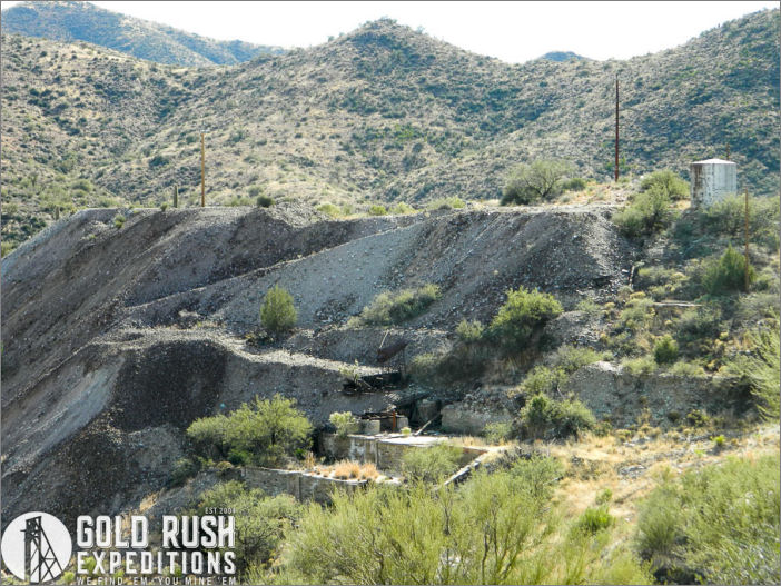
 The property has over 369,000 tons of waste dump that assay from .48 to over 2 oz/T AU. There are also at least 240,000 tons of tailings from the mills. These tails assay from .23 oz/T to .68 oz/T AU. The overall value of the operation is defined from the value of the waste dump and the tailings if processed.
There is extensive speculation on values of the ore body known as the Golden Belt which runs through the property. The lode system is reportedly horizontal and flat with extensive horizontal shoots from 100 to over 600 in depth showing high-value native gold deposits.
 The dumps and tailings were surveyed and measured in 2019. The tailings are measured to be at least 240,600 tons. The waste dumps are measured at 369,700 tons. High-value grab samples taken from the lower edges of the waste dumps assayed at .78 oz/T AU. The tailings were sampled from the tops of the piles, gathering a large bucket of various material. The tailings assay values returned at .604 oz./T AU. Both values are consistent with the return values from reports of 1961, 1971, 1973 and 1985.
The numbers show that the waste dumps contain roughly 288,366 ounces of gold and the tailings contain 145,322 ounces of gold. A total of 433,688 ounces with no accounting for underground deposits or development.
In todays figures, with gold assumed at $1500.00 per ounce, the dumps and tailings piles would be worth over six hundred and fifty million dollars($650,532,600). This figure does not account for any of the ores or minerals still left in place underground. According to geological documentation, the richest bodies of the veins have yet to have been tapped. From the 1973 report[1]:
There are excellent geologic structures on all of the claims where, thru core drilling, a large tonnage of are can be developed. All of the mine has been developed laterally, just under the surface rock, to the point where the veins turn down vertically. The vertical vein deposition is contacted on the west side by an intrusive diorite dike, and is the parent vein. At the present time, no one has drilled or shafted downward into these vertical veins. There can be developed, with sound operation, very large amounts of high grade ore from these vertically orientated veins.
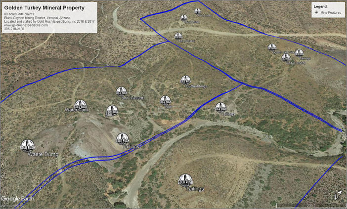
 The mines are located on the south-eastern edge of the Bradshaw Mountains. Near the towns of Mayer and Spring Valley. 60 acres total covering all of the workings of the Golden Turkey and Gold Belt Mines which are interconnected underground.
The property was remediated in 2010 as well as can be ascertained and the main portal is gated. The gate will need to be removed and the decline cleared to provide access to the lower workings which are documented to be well over two thousand (2000) feet. The underground workings are in a deteriorated state and should not be accessed in their current state.
There are remnants of many buildings on the claim. Private housing, an assay shop, and miners quarters in addition to the mill and mine building remnants. Vandals are reported to have burned the last of the standing structures, the assay house, in 2006.
 This property is targeted to the development of the surface material which has been largely overlooked for the past 30 years. There is definite value and high profit for the operator who can manage to ship and process the ores on site and continue that development into the Golden Turkey and Gold Belt veins.
[1] Jones, Melvin, 1961. Nezona, Inc. Mines, Geology Reconnaissance Report
Asking Price: $184,000
Contact: Gold Rush Expeditions
Use code JRM1003 for a 10% discount.
www.goldrushexpeditions.com
Ph: 385-218-2138
Email: goldrush@goldrushexpeditions.com


