Historic Arizona Rand (ROADSIDE) Mine and Camp
20 Acre Lode Claim Oatman District
Mohave County, ArizonaContact Gold Rush Expeditions
Use code JRM1003 for a 10% discount.
www.goldrushexpeditions.com
Ph: 385-218-2138
Email: goldrush@goldrushexpeditions.com
Gold Rush Expeditions, Inc. is proud to present the Historic Arizona Rand Gold Mining Claim for sale. This is a 20 acre lode mining claim for sale exclusively through Gold Rush Expeditions, Inc. The Arizona Rand is located just outside of Bullhead City, Arizona and has been properly staked and marked at all corners. All Gold Rush Expeditions, Inc. claims have been meticulously surveyed, mapped and researched. Field work is completed by our own experienced, well versed Mine Survey Team.
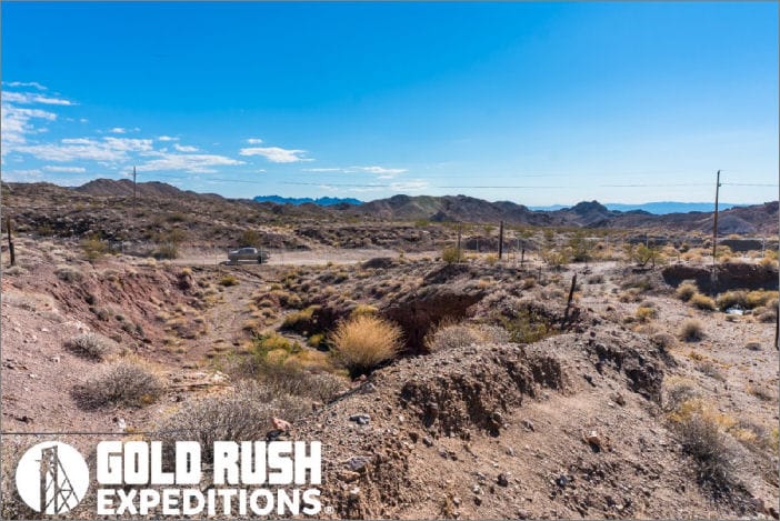
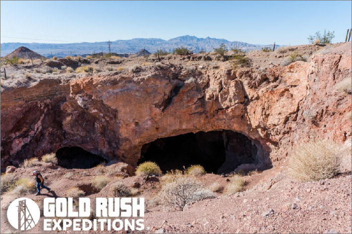
The Arizona Rand is also more recently known as the Roadside Mine. The mine has been absorbed by the Katherine Gold Mine conglomerate and worked at a great profit for many years. The mine as it sits today consists of a large stoped cavern with some unmapped drifts and winzes.
 The Mine was documented in 1996 by the USGS as having a minimum of 136,000 metric tons of gold ore reserves at an average value of .30 OPT. With gold at $1200 an ounce, thats a value of over $48,000,000 (million).
It is a massive development which clearly showcases veins of gold ore along with some defined copper and sulphide silver. It is a commercial size deposit and working that could be worked by a small group of miners under casual use, or it could be restored to a commercial operation with the substantial reserves. The mine was abandoned when the Katherine Mine went bankrupt, and has been held by smaller companies for the past 20 years.
Access to the mine is clear on county roads and the mine can be accessed with a 2WD vehicle. There is ample parking and staging areas for most any need or use.
This is a large operation and will require some permitting for a full production operation. This mine would not be feasible for a casual use operation. Owner operator will need to extract and process gold ore by the ton. Gold Rush can assist in filing of documentation and legal guidance at clients request.
History of the Mines
The Arizona Rand or Roadside Mine as it has been known, has a long history of production and developments. It is a working gold mine with defined and documented reserve ore bodies consisting of gold, silver and copper. There are over 100 pages of documentation detailing the drilling and sampling of the mine over the past 40 years.
At the Roadside Mine the shaft was sunk to the 100-foot level in 1915 and 1916 and later extended to the 300-foot level. It had two compartments and was at an incline of 70 degrees. Up to January 1934 the Gold Standards had done about 1,000 feet of development work on the 100-foot level and produced 890 ounces of gold and 1,734 ounces of silver. In May 1935 the last of the ore from a shrinkage stope was being drawn; in January 1936 the mine was closed.
A chimney shaped are shoot with a flat rake to the north extended from the surface to the 100-foot level. It was 20 to 35 feet wide and 75 feet long on the strike. The ore averaged 0.28 ounce of gold to the ton. Despite the flat dip of the vein, the are was mined by a shrinkage method. In March 1934 about 10,000 tons had been broken, but only the swell had been pulled. Plans called for using a scraper for emptying the stope.
Chutes were 25 feet apart with pillars left between them. Although only a few pillars were left in the stope, no caving of the back occurred.
In the spring of 1935 the are was being mined by one machine miner, two men with hammers in the stope, two trammers on the 50-foot level, one bucket loader, and one topman. Hoisting was done in a 1,000-pound bucket and tramming in 16-cubic-foot cars running on 18-gage track. The water was kept down in the shaft by pumping two shifts each day with a boiler feed pump.
 The following review of the property history is excerpted from Kirwin (1990).
The individuals who comprise ONANON Inc. began acquiring claims in the district during the late 1960s. An unknown group drilled 19 or 20 churn drill holes (at the property) before. Fischer-Watt leased the property from ONANON Inc, in 1984. The records from that period are fragmentary and do not aid measurably in understanding the deposit. Fischer-Watt drilled 28 reverse circulation holes in 1984 most of which were drilled at the Roadside(Arizona-Rand) mine. Anaconda sublet the property from Fischer-Watt and drilled ten diamond drill holes for 2,780 feet in a reconnaissance fashion throughout the claim block.
The reboxed core is now stored on the property in a recently completed core shed. Anaconda released their lease in 1985. Fischer-Watt drilled 15 Rye holes for 4,230 feet in August, 1986 to fulfill assessment requirements. Most of the holes were drilled in a reconnaissance fashion although a few were drilled at the Roadside (Arizona-Rand) mine. It was observed in the field that many of the 1986 Fischer-Watt holes were drilled into the footwall of mineralized structures parallel or subparallel to the dip of the structure, rather than crossing the structure from hanging wall to footwall. Nevertheless, several of the holes contain anomalous gold values. Fischer- Watt relinquished their option on the property in 1986. Ivy Minerals leased the property from ONANON in 1987, and carried out several drill programs on the Roadside (Arizona-Rand) Mine. Although some of the holes were drilled with a reverse circulation rig, many of them were drilled with a company owned track mounted percussion rig with a depth capacity of 100 feet. Most of the air track holes did not reach the mineralized zone at the Roadside mine. Ivy Minerals sublet the property to ACNC in July, 1989. During August, 1989 ACNC drilled 53 RYC holes to depths of 100 feet each to fulfill assessment requirements and to explore beneath the alluvial cover on the pediment. All holes reached bedrock but most did not intersect altered rocks. Preliminary mapping and sampling, during the Fall of 1989 indicated that the Gold Chain Little Gold Chain Hill prospect should be drilled in 1990. Two more phases of drilling were completed during 1990 evaluating the Gold Chain area as well as several reconnaissance targets on the pediment. In July, 1990 ACNC canceled the lease agreement with Ivy minerals.Contact: Gold Rush Expeditions
Use code JRM1003 for a 10% discount.
www.goldrushexpeditions.com
Ph: 385-218-2138
Email: goldrush@goldrushexpeditions.com


